The experience
The Wool and Silk Road: through the Tuscan-Emilian Apennines
The Wool and Silk Road is a path that starts from Bologna and arrives in Prato.
The thread that unites the two cities is linked to the textile industrial tradition.
The way allows us to deepen this link by following natural and artificial evidence that tells of these past times.
On all the two hydraulic works symbol of the route on the Reno and the Bisenzio: the Chiusa and the Cavalciotto.
The Wool and Silk Road is dotted with museums and places dedicated to the history of looms: in Bologna the “Vittorio Zironi” Museum of Textiles and Upholstery, in Vernio the MU. BUT. T Museum of Textile Machinery, in Prato the Textile Museum, in the former Campoli factory, an excellent example of recovery of industrial archaeology.
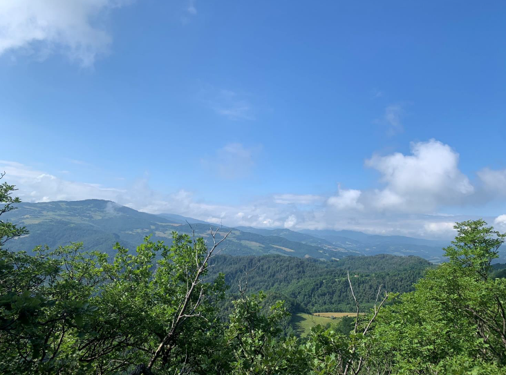
The route winds through paths rich in history and traditions and walks immersed in the wild nature of the Tuscan-Emilian Apennines.
The time needed to travel the 130 kilometers is 6 days (on foot 6 stages of about 23 km).
Many stages have detours that allow you to encounter interesting sites.
For example, in many places the Wool and Silk Road intersects the Gothic Line: the path gives right memory to many places of sad memories linked to the fierce clashes of the Second World War.
This itinerary has been created in synergy with “Smart Walking”, Davide Fiz’s project that combines trekking and agile work, to enjoy tourism and work slowly, with a backpack on your shoulders and the desire to discover the historical and naturalistic heritage of our territories!
Shortly
Tour
Bologna to Sasso Marconi
The Wool and Silk Road begins from the historic center of Bologna, from Piazza Maggiore.
From there go in the direction of Due Torri and take Via Oberdan (left) and follow it to the view of the Reno canal.
We reach Via Augusto Righi with a stop in Via Piella where we can see the famous window on the Moline canal and from there Via Indipendenza – Via dei Falegnami and Via Riva di Reno.
After Via San Felice you arrive in Via della Grada (you will see the tower with an iron grate for filtering water) and, after passing “the Spinning Mill” and the power plant, continue towards Via Martinez, a cycle-pedestrian avenue, towards Casalecchio.
The Wool and Silk Road climbs the canal along the right bank.
Cross the Porrettana road towards the entrance to the Chiusa consortium and continue towards via Giordani – Prato Piccolo river oasis.
Climb the ruins of the ancient Chiusa of the fourteenth century to admire the amazing work of Jacopo Barozzi, the Vignola, which still protects Bologna from the floods of the Reno.
Enter the Parco della Chiusa by returning again to the Porrettana crossing the red and white CAI 112 Via degli Dei sign.
You walk along the tree-lined avenue and skirt the Boccaccio which imprisons the waters of the Reno and then discharges them into the canal.
A large wall contains the left bank, with two hatches equipped with sluice gates for hydraulic adjustment, the elimination of silt and gravel and a system for discharging surplus water into the Rhine.
Leaving the canal, walk in the direction of a floodplain forest up to a large iron bridge that will allow you to cross the Rhine in a left-hand direction.
Here ancient sand quarries have been used to obtain sport fishing or water containment tanks to be used in case of emergency.
An underroad tunnel will take you past a factory and then lead you down a tree-lined avenue towards the north entrance of Palazzo de’ Rossi, a Renaissance complex formed by the village, mill, sawmill and paper mill powered by the driving force of the Rhine.
When you reach the intersection with Via Ancognano, you will find the CAI 112 – Via degli Dei path with which you share the path up to Sasso Marconi.
At the intersection with the provincial road 37, continue towards Sasso Marconi on the right and, after passing an iron gate, a yellow building (the accesses to the Prati di Mugnano), the motorway overpasses and the bridge over the Reno, you enter Sasso Marconi.
Stage 1: Bologna – Sasso Marconi
Km 20 Maximum height 230 a.s.l.
Time: 6 hours
From Sasso Marconi to Grizzana Morandi
We continue the Wool and Silk Road.
From the town hall square, turn into Via del Mercato and then arrive on Viale Kennedy.
Arriving at the roundabout of the Marconi monument, cross the bridge over the Reno and go towards Vado up to the bridge over the Setta.
After crossing the bridge over the Setta, turn left into Via Sirano and once you arrive at Casa Bergamini, take a chub up to the cemetery of San Silvestro where you join the CAI 100 path – path.
From the church and cemetery of San Silvestro (where the variant from Sirano arrives – now impassable due to a landslide), an open and panoramic ridge opens up with a view of the hills and the prestigious vineyards of the Bolognese hills.
At an altitude of 500 m, CAI junction 128, go around the La Volta farmhouse and, still on CAI 100, reach Monte Santa Barbara (591m).
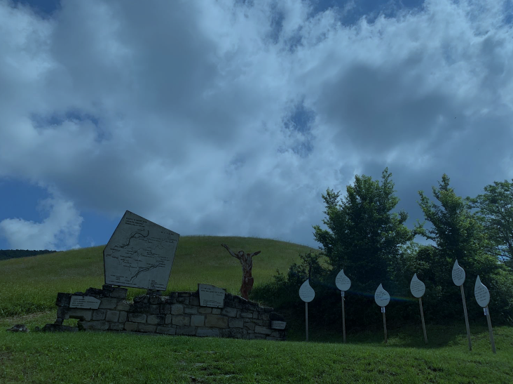
In the locality of Nuvoleto you arrive in 30 minutes at a junction between trail sign 100 towards the top of Monte Sole (668m) and trail sign 100A, towards the star of Monte Caprara (632m) where it rejoins the 100 that descends from Monte Sole and the monument dedicated to the Wolf and the partisans of the Red Star.
After passing the ruins of Capraia di Sopra, you reach a dirt road and then a paved road that leads to an important crossroads, a junction between the monuments of the memorial and the Poggiolo Visitor Center.
We take the path to San Martino – Monte Sole school of peace – San Martino cemetery and monument to Don Giovanni Fornasini, the place where citizens and institutions commemorate the Liberation every year.
After the junction for Concola and the monument to Don Ferdinando Grande (Mount Termine), the vegetation changes and you can see the Scots pine, a native and protected nucleus.
Keep the signs for Veggio and after about 100 meters enter the woods to climb to Mount Salvaro (826m).
On the sides of the path there are a large number of trenches, foxholes, shelters, witnesses of the war and the clashes between the Germans and the Allies.
On the plateau we find an iron cross and a shelter useful in case of rain.
Descend along the ridge line to a dense forest of junipers and other specimens of the park’s natural scrub and so on to the gates of Grizzana Morandi.
Continue towards Monte Pezza (752m) along a rocky track and cross the localities of Cà la Fame and Cà la Sete on path 174.
Stage 2: Sasso Marconi – Grizzana Morandi
Km 27 Maximum height 1400 a.s.l.
Time: 8/9 hours

From Grizzana Morandi to Castiglione dei Pepoli
Third stage of the Wool and Silk Road.
From the town hall, continue in the direction of Stanco, a fourteenth-century village and continue on the pedestrian avenue that runs alongside the monument in memory of the 11 victims of 22 July ’44.
Once you reach the junction for Tavernola, continue and arrive in the locality of S. Abramo where path 100 enters a forest of chestnut trees and meadows up to the outskirts of Collina.
Climb and skirt the ballast of Palazzo Vannini and, along a gravel road, reach the top of the ridge and then descend and cross the provincial road 73.
go up in the direction of Boscalto and a crossroads of roads that descend towards the valley of the Rio Vezzano and the center of Burzanella.
The Wool and Silk Road continues towards the Matelle locality and once in La Latra, after passing two centuries-old oaks, you arrive at a crossroads with a majesty.
Take a dirt road towards La Rocca and, after passing the Lagacciolo stream, pass some buildings and enter Burzanella.
Once you reach the locality of Bel Poggio, continue climbing on a cart track to cross the 039 in the locality of Il Logo.
After leaving behind a votive shrine, you enter a coppice forest up to 930 meters of Mount Fontanavidola and Cà Terre Rosse.
Take the 031 to Castiglione dei Pepoli and pass loc. The Walls.
After the paved road, take a dirt road that crosses agricultural areas between streams and ditches.
From Cà delle Vigne you pass the Brasimone stream which also feeds Lake Santa Maria here.
To get to Castiglione, the Via della Lana e della Seta continues straight ahead and you walk along the entire lakefront of Santa Maria where you can stop for a break and start climbing along the CAI 031 path to the Ca’ di Lenzi locality and then continue towards Castiglione.
Here turn right towards the center of the village is about 500 meters away.
Stage 3: Grizzana Morandi – Castiglione dei Pepoli
Km 22 Maximum height 1100 a.s.l.
Time: 7 hours
From Castiglione dei Pepoli to Vernio
We continue the Wool and Silk Road.
Starting from Piazza della Libertà in Castiglione dei Pepoli (where you can admire the Clock Tower) first walk along Via San Lorenzo, then Via Saliciata and finally Via Manfredi.
This will take you to the intersection with Via Dall’Olio from which you can take the CAI 035 path.
This will take you to the top of Monte Bagucci, continuing to a forest road that leads to the Abetina and the Ranuzzi Refuge.
From here you will have to change path, walking along the CAI 037 to Bagucci-Rasora-Spinareccia.
The Wool and Silk Road then crosses a wooden bridge over the Rio Secco, continuing on a mule track that will lead you to Rasora, a small typically mountain village.
Once you reach the central square, continue towards the ruins of the Mulino della Sorgiva and cross the wooden bridge over the Rio Fobbio, until you reach the dirt road that leads to Spinareccia.
Once we reach Storaia (former border area between the Grand Duchy of Tuscany and the Papal State) we cross the bridge over the river and leave path 027 that goes up to Tavianella, we take a right to follow the orographic right of the Setta river in a path with some short impervious stretches until we reach Montepiano.
A beautiful town rich in history and famous for its villas.
Pass the junction that leads on one side to the Abbey of Santa Maria and on the other to the Parish Church.
Here you will have to turn into via Monsignor Risaliti then, after skirting the cemetery and a parking lot, continue to the Passo della Crocetta.
From here, among chestnut, fir and beech trees, continue walking until the junction for the CAI 58 path.
At this point keep right until you reach Butia, then Gorandaccio and finally San Quirico di Vernio.
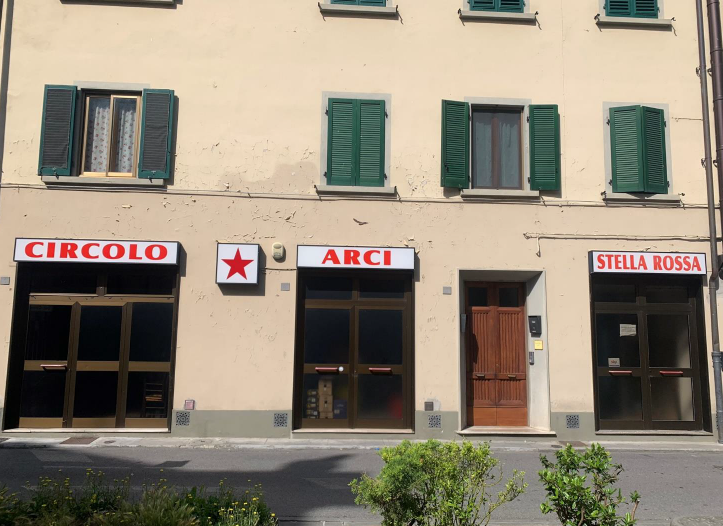
Reach the main square (where you will find the old Town Hall, a chapel and a “permanent exhibition” themed Gothic Line) and thus the conclusion of the stage, at the Circolo Arci Stella Rossa.
Stage 4: Castiglione dei Pepoli – Vernio
Km 20 Maximum height 800 a.s.l.
Time: 7 hours
From Vernio to Vaiano
With the fifth stage of the Wool and Silk Road you will leave woods and fir forests behind, continuing your journey along the ridge of Calvana, rugged and rocky, which once housed the bed of the ancient Bisenzio.
We start our journey starting from the Circolo Arci Stella Rossa, from here we head towards Piazza San Lorenzo and then Via della Pioggia Alta and Via delle Soda.
After the junction for the Corboli farm, we reach another one, from which we will take the CAI 60 path to the Cotone farmhouse and, after the latter, to the locality of Le Soda.
At this point, take path 20 to Dogana and, from the dirt ridge, reach Montecuccoli.
Continue on the CAI 20 route until the intersection with a cart track that leads to Santo Stefano (a place of sheep farming).
Here we officially enter the territory of Calvana, and continue the journey passing Poggio Montecuccoli, Poggio Brioli and Masso di Costa, thus entering an area that has small reforestation of pine trees.
Once we arrive at Monte Il Prataccio we continue walking in the same direction on path 46a, towards Vaiano.
After passing the Fosso and the Fonte del Favo, the path descends from the Passo della Croce among shrubs and brooms, reaching the village of Sofignano.
CAI 46 ends, but it will be enough to continue along Via di Sofignano to get to the village of Le Fornaci, where lime was once produced.
At this point we take Via di Larciano, a gravel road that winds through dry stone walls, vineyards and hedges.
Once you reach the junction with Via di Moschigiano, turn in that direction to reach the village of Vaiano, where you can admire the ancient Abbey of San Salvatore and the museum dedicated to wool processing.
Stage 5: Vernio – Vaiano
Km 21 Maximum height 1000 a.s.l.
Time: 7 hours
From Vaiano to Prato
Last stop on the Wool and Silk Road.
From the square of the municipality of Vaiano, walk along Via Alessandro Vannoni to Via Fratelli Rosselli.
Continue towards the station and then take via Borgonuovo, then via Bronia and again via di Sofignano, up to the Villa di San Gaudenzio.
Continue along the uphill road to Le Mura and then, after crossing a gentle hilly area, you reach Collisassi.
From here a cart track will take you to Le Cave and then to the Passo della Croce, from where you can resume the CAI 20 path that continues along the ridge of Calvana in the direction of Monte Maggiore.
You must then continue on route 40, which enters the valley of the Rio Buti, where you can observe 5 horizontal caves with karst springs.
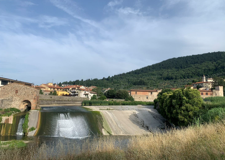
We now begin the descent towards the valley floor on the Via di Valibona, towards the Cavalciotto di Santa Lucia (a work that was used to convey the waters of the Bisenzio towards the city, allowing the development of the activities of mills and factories).
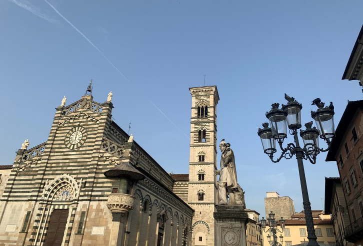
From here we cross a metal bridge over the Bisenzio and then continue on the cycle path that, through the Porta Mercatale, will lead us to Piazza Duomo in Prato.
Stage 6: Vaiano – Prato
Km 22 Maximum height 900 a.s.l.
Time: 7/8 hours
Let us guide you on your journey to the Roots
Don't miss the opportunity to explore the places that have shaped your origins, request a tailor-made itinerary without obligation

